
Mapping the Stormwater System
It’s day 2 of Stormwater Awareness Week 2025, and today we’re challenging you to get to know your neighborhood storm system!
The City of Kirkland’s Storm & Surface Water Division ensures the proper maintenance and operation of all public and private drainage systems within the city. Kirkland’s Storm & Surface Water Division is responsible for:
- 427 miles of pipes and culverts
- 15,615 storm drains
- 1,102 detention tanks and vaults
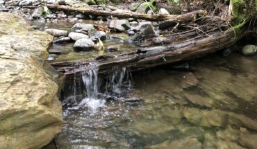
- 36 miles of stream, 3 large lakes, and over 400 acres of wetland.
To keep track of all this, the City’s GIS team helps maintain our mapping system so that we can see how the storm system works in our neighborhoods, and how it interacts with topography, soils, and other infrastructure.
Many of the GIS tools that City staff use are also available for the public to use online! However, we know these aren’t always intuitive tools to use, so we made a guide to help walk you through the online GIS tool and to get to know your friendly neighborhood storm system!
Our challenge to you is to follow the path your storm system takes from the nearest storm drain to your house, all the way to the nearest outfall – the place where the system empties into the creek, lake, or stormwater pond or vault.
Step 1 – Go to Kirkland Cityhub online: https://kirklandwa.maps.arcgis.com/home/index.html
This mapping portal has all kinds of resources on it, with more being added. For mapping the storm system, click on “City of Kirkland – Kirkland Maps” on the top left of the grid. This will take a few seconds to load. 
Step 2 – Find your address:
- On the top bar, select “tasks.” A new menu will pop up.
- Select “address” from the menu
- Enter in your address into the search bar. NOTE – this system likes correct abbreviations without punctuation. It does not like fully spelled out words such as “street” or “lane.” For example “123 5th Avenue” wont work, but “123 5th Ave” will.

Step 3 – Change the Layers
- There is a blue button that says “I want to…” – click that, and select “Change visible map layers.”
- “Base Map” is the layer that will already be selected. Click the + sign next to it so see all the layers that are included on the base map.

- Turn on and off layers in the base map by clicking the check boxes next to each option. We like to turn off some of layers that we aren’t interested in to reduce visual clutter while leaving enough information to help up understand the map at-a-glance. Have fun exploring and playing around!
Here are the layers we recommend:
- Turn OFF:
- Grid
- QQ Grid
- Regional Rail Corridor
- Major streets
- Cross Kirkland Corridor
- Place names – if they make things too cluttered
- Turn ON:
- Easements – you might have one on your property and not know about it, so it’s always good to check!
Our base map for City Hall now looks like this:

- Hit the – button next to where it says “Base Map” to close all those layers
- Check the box next to “Utilities” and hit the + sign. “Storm System” should already be selected. If it isn’t, select that box
- Hit the + sign next to “Storm System” and select the box marked “Storm pipe flow direction”
Follow the arrows! Where does your storm drain connect with other pipes? Can you find the place where your storm system flows into a body of water?

We traced our storm system from the grate outside our offices to Lake Washington!

Hoping to save your work? You can print, or print-to-PDF, from the “Home” menu! This will give you a map with a legend on it so you can remember what all the lines and colors mean later. You can change the scale of the map and the quality of the print. If you want to drag the map around to hone in on the area you want to print, deselect the “lock print preview with map” box at the bottom.

Curious about some element of your map? Click on “Identify,” then select an area of map you’re curious about. All of the mapped elements in that area will appear on the left, and you can click on any of them to learn more! We like exploring the storm record drawings, which will sometimes show you the original plans for your whole neighborhood!

You can use these maps to explore other elements of Kirkland infrastructure too! Have fun playing around, and don’t forget to check out some more of the information on the mapping homepage to explore cool community highlights!


Please review our comment policy before leaving a comment